| Geospatial in India
The worldwide market for Geospatial Information Systems is forecast to grow 65 percent over the next five years, representing a compound annual growth rate of 12 percent. It is expected that the annual growth rate will slightly exceed GDP for 2011 and 2012 as global economies continue to recover. Figure highlights the percentage growth for the Indian geospatial industry vis-a-vis worldwide growth.
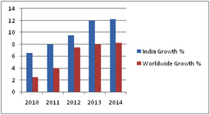
Fig: Growth of Indian Geospatial Industry vis-a vis worldwide growth
Geospatial information is crucial and significant when we talk about India as a developing nation. The public sector organisations are recognizing the value of geospatial for decision support and the private sector orgnaisations are using it as a tool for market development. If we talk about the development and escalation of geospatial industry in the region, it is really very prominent, with mature players having marketed the benefits of geospatial information over the past two decades. Indias reputation as an outsourcing destination has also played a role, enabling the country to develop significant technical expertise in the geospatial arena.
One of the most promising developments in Indias geospatial industry has been the opening up of mapping data and information by the state. This is enabling government bodies and the private sector to actively participate in the advancement of the industry. Lot of businesses and Industries are using geospatial services in India for analysis of demography, competitiveness, expansion, risk management, target oriented marketing, planning of route etc.
Sectors using geospatial Services in India:- -
Health Care use geospatial for marketing, promotion, research and development
-
Central and State Governments use geospatial for development in economy, reforms for the legislation, administration registration for the voters, emergency management etc
-
Logistics use geospatial for scheduling, routing, dispatch, tracking, and operations in the warehouse
-
Agriculture use geospatial for the analysis of production, pollution control, targeted agrarian production
-
Telecommunications department use geospatial wireless engineering, routing of communication network, customer support, target oriented marketing, construction management
-
Gas and Electric companies use geospatial for engineering planning and designing, customer service, distribution system management, marketing, power generation and management of load, meter reading, billing and collection
-
Petroleum Industry uses geospatial for exploration, distribution, and retail
-
Environmental management use geospatial natural resource management, water quality, waste management, groundwater modeling etc
-
Public Safety units use geospatial as a constitutional part of emergency response systems formulated for man-made and future disasters
-
Forest Department use geospatial for the mapping of flora and fauna
-
In an Enterprise, GIS application is used to ensure that all departments within an organization have access to geospatial information
-
In Infrastructure Industry geospatial is being used in planning, implementation and development of existing and new infrastructures.
|
|
|